


Heavenly Red Canyons, A Monumental “Reef,” and Pioneer Pie in the Beehive State
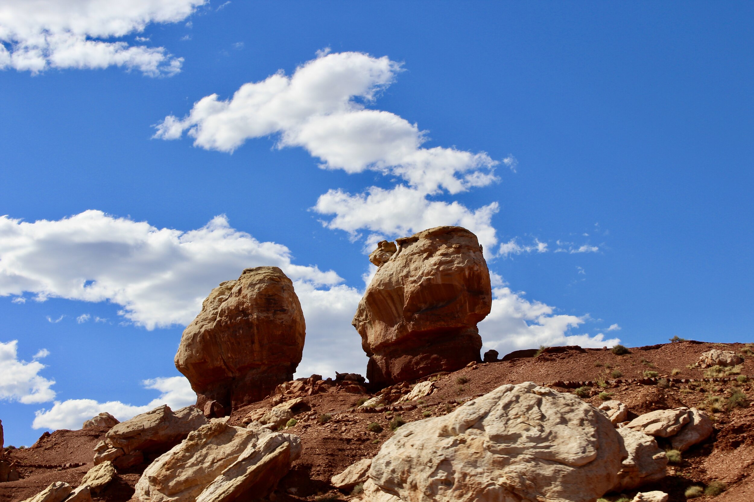
The immense Twin Rocks in Utah’s Capitol Reef National Park.
From June 6 to June 18, 2020, I drove from Los Angeles, California to Chicago, Illinois in a Buick Enclave. The car, filled to the brim with my college possessions, took me over 4,000 miles up the Pacific Coast, through the Sierras and Rockies, and across the Great Plains. It traversed the roads of ten different states and coasted along the scenic byways of six national parks. Along the way, we drove by Johnny Cash’s home in Casitas Springs, California and John Wayne’s birthplace in Winterset, Iowa. We visited tributes to iconic generals from Grant to Custer. We marveled at the world’s largest tree, reminisced over ancient history at one of the planet’s premier fossil sites, and braved the country’s highest paved road. We came across stately bull moose, emerald pools surrounded by red cliffs, scurrying prairie dogs, homemade apple pie, the world’s only corn palace, dinosaur tracks, a giant rock protruding out of the sea, “thunder beasts,” a double rainbow and the stuffed remains of the mythic jackalope among many other things. Climb in and buckle up as we embark on the Natural Curios Road Trip!
To read part one of the Naturally Curious Road Trip, Click Here!
Paradise Etched in the rocks
Mormon settlers first entered the canyon known to the local Piute Native Americans as Ioogoon in 1858, hoping to find any tract of arable land in the barren and sweltering Southern half of Utah. As they continued down the Virgin River, they found much more than they were seeking. In fact, it seemed to them like they had ventured into heaven on earth.
The signs of the spiritual enlightenment these pilgrims found here becomes more apparent as you travel deeper into the canyon and become acquainted with the rocks that tower overhead. A nearly 1,500 foot tall rock, often referred to as an “island in the sky,” is called Angel’s Landing. Deeper into the canyon, an even taller monolith of bright white rock is known as the Great White Throne. Even the canyon itself is named after a biblical place of paradise: Zion.
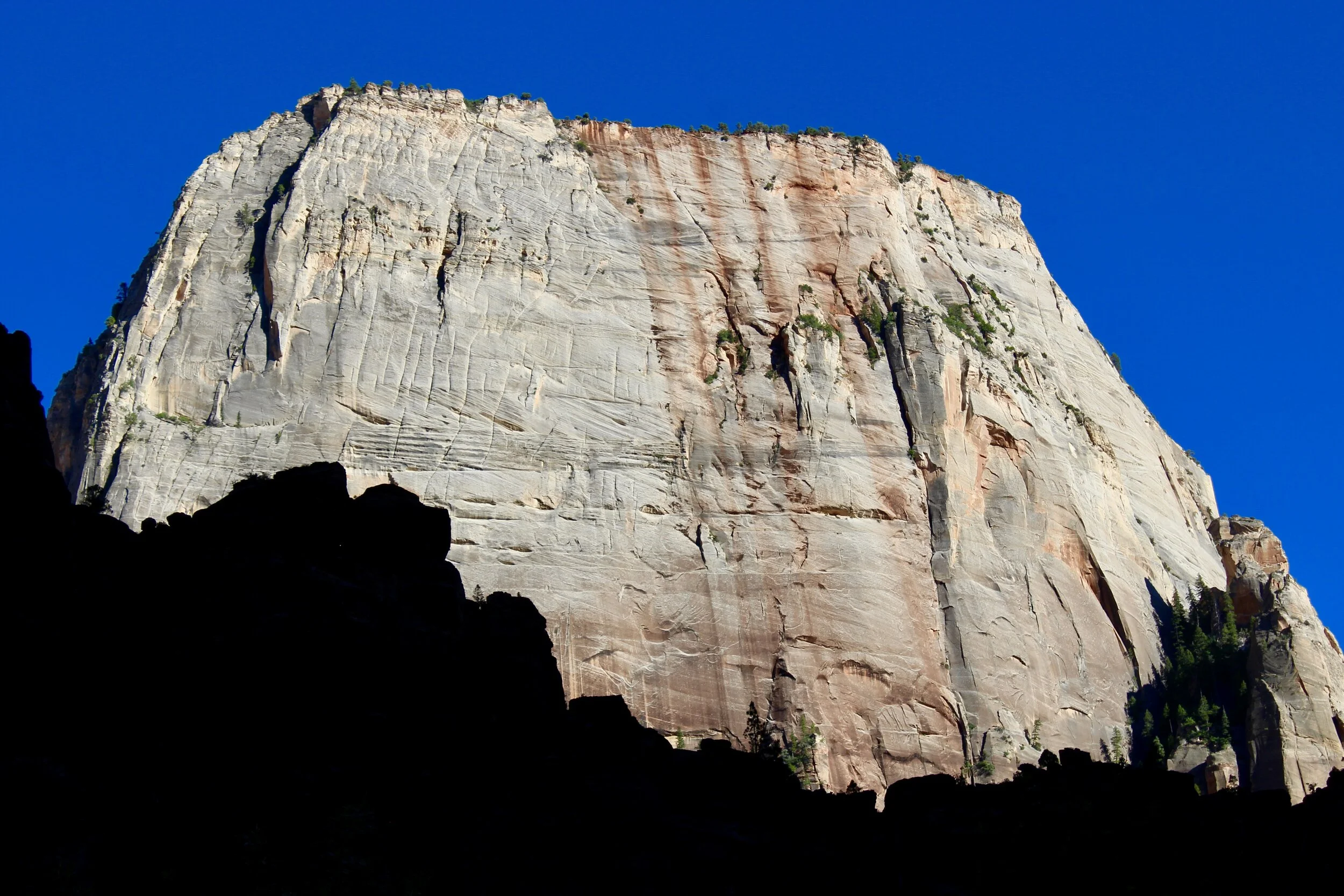
Great White Throne rises dramatically over the rest of Zion National Park.
Although the setting seemed heaven-sent, life on the canyon floor was anything but. The early Mormon settlers only found pockets of suitable land for agriculture. Flash floods and devastating droughts were constant threats. But they persisted, like the Piute and Anasazi Peoples before them, until the park was set aside as a national monument in 1909. Ten years later the area became Zion National Park.
The rocks of Temple of Sinawava glow red in the setting sun. Further along this trail, the canyon’s constrict to a mere 20 feet wide in an area dubbed the Narrows.
Similar to the holy names of the rocks inside Zion, the town of Springdale harkens back to early Mormon settlers. Founded in the 1860s and brimming with souvenir and fossil shops (and thankfully a laundry mat), Springdale sits right outside of the park’s boundaries, welcoming all types of modern-day pilgrims as they seek spiritual wisdom in red rocks. We drove through Springdale on June 9th, a hot Tuesday afternoon, after traversing Nevada’s desolate interior and the top corner of Arizona. California’s sequoia groves were a distant memory as we entered Zion National Park, hoping to find paradise etched in the rocks.
In the Beginning, Everything was Flat
The genesis of Zion’s striking rock formations dates back some 270 million years, when this area sat under a shallow, tropical sea near the equator. As the continents drifted on top of the earth’s crust, Zion’s environment changed from a warm ocean environment to a muddy floodplain to a windy desert covered in massive sand dunes in a span of a 100 million years. As Zion’s spot on the globe shifted, massive amounts of rock from higher altitudes was deposited here, either by wind or water, eventually causing the shallow basin to sink under the considerable weight of the giant piles of rock. Eventually, the amount of rock deposited here from the eroding mountains was 10,000 feet tall.
These giant piles of rocks eventually became cemented into the steep walls of Zion Canyon thanks to the slow filtration of water, substantial pressure from the rocks above, and most importantly, a very long amount of time. The same tectonic forces the moved this area around the earth also caused the earth to steadily uplift, eventually raising the compacting rocks of Zion thousands of feet above sea level. This uplift did not only occur in Zion, however. The Grand Canyon to the south was also part of this uplifted area, known as the Colorado Plateau, as is nearby Bryce Canyon. As you travel south from Bryce Canyon to Zion Canyon to the Grand Canyon, you are descending a geological feature known as the Grand Staircase. This set of “steps” refers to the increasing age of the rocks. Therefore, the oldest (bottom) layer of rocks at Bryce Canyon is the youngest (top) layer of rocks at Zion. Continuing south, the oldest layer of rocks at Zion is the youngest layer of rocks at the Grand Canyon.
This deep geologic history is most beautifully rendered in the rich palette created by this layering of rocks in the canyon’s walls. One of the earliest explorer’s here, Major C. E. Dutton who surveyed the area in 1880, beautifully summed up the polychromatic nature of Zion: “The slopes…display colors which are truly amazing. Chocolate, maroon, purple, lavendar magenta, with broad bands of toned white, are laid in horizontal belts…like the contours of a map.” Almost a century and a half later, the splendor of Zion’s colorful rocks still remains. The different-colored bands that Dutton described are arranged from oldest at the bottom to youngest on the top and are composed of different types of rocks that date back to the ancient habitats that were once found here. The primeval ocean of 270 million years ago is rendered in gray siltstone. The 210-million-year-old flood plains represent a crimson band of mudstone. A thick layer of pink sandstone dates back from when this area was a sandy desert 180 million years ago.

One of Zion’s spectacular red-hued arches along Zion Mt. Carmel Highway in the Park’s eastern end.
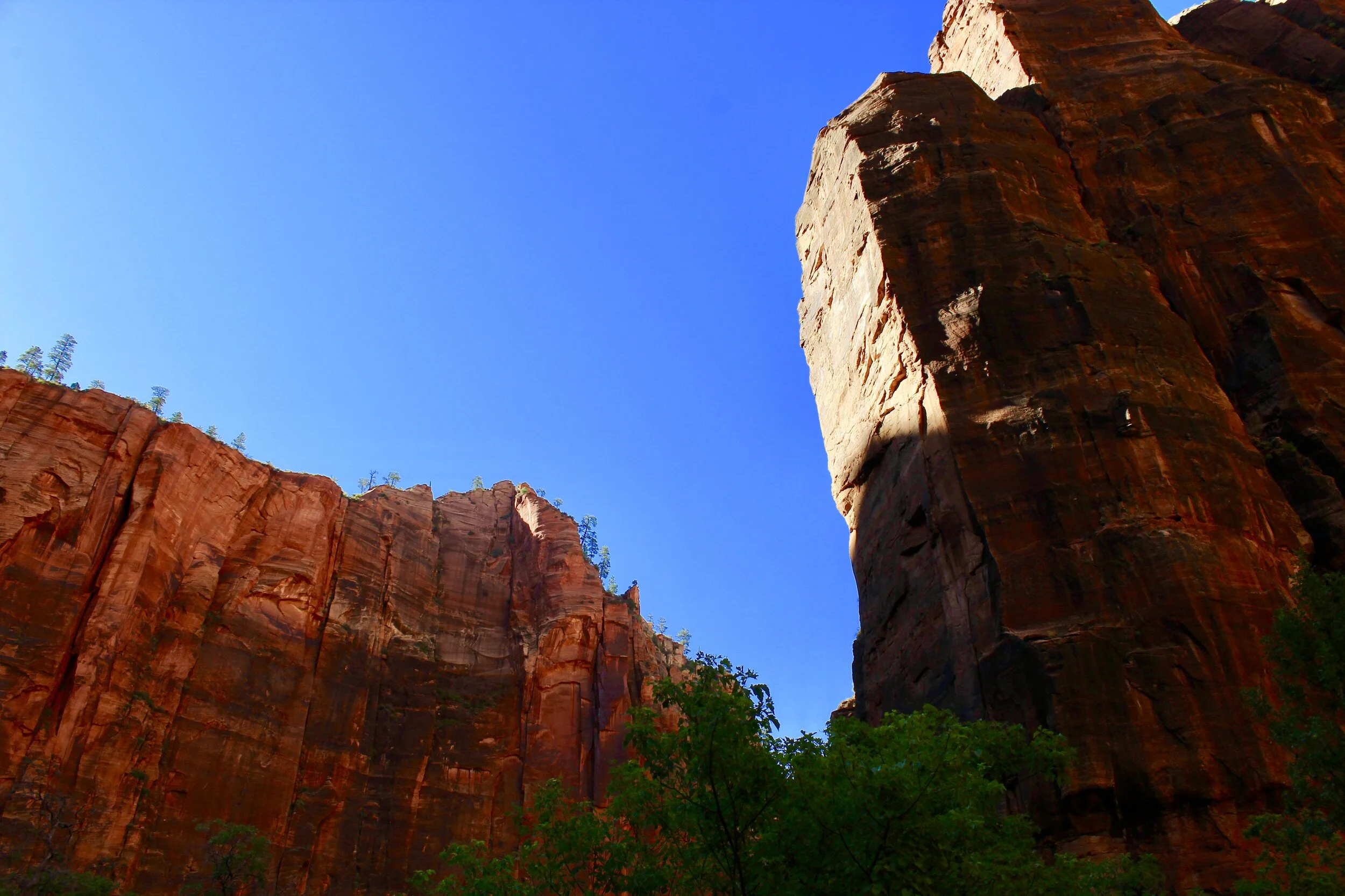
Zion is at the western edge of the Colorado Plateau, which means it bears the brunt of a gush of water desperate to eventually descend to the ocean. As the river falls off the edge of the plateau, it travels down a steep gradient, picking up speed similar to a rollercoaster flying down a precipitous drop. Fast-moving rivers are particularly adept at carving canyons because they can easily carry away large chunks of rocks and boulders as opposed to slower rivers. One of Zion’s most famous attraction is a tall and tight canyon where the Virgin River has just sliced through the rock. This created a dramatic chasm that rises up 2,000 feet and restricts to 20 feet wide at some points, giving this area the claustrophobic moniker of The Narrows.

The Virgin River meandering through Zion Canyon.
Today, the rest of the canyon is thankfully much wider, offering ample space to move through this hiker’s paradise. We drove along the one road that winds through the heart of the park towards the Zion Lodge, a historic wooden hotel nestled in the shadows of the surrounding sandstone cliffs. Originally completed using 265,000 feet of lumber in 1925, the main lodge building was soon surrounded by a smattering of log cabins that offer the only place more substantial than a tent to stay within the park boundaries. Although the original Zion Lodge building succumbed to fire in 1966, the new structure that quickly replaced it still possesses an archival feel thanks to its chocolate-colored wood and unnaturally green roof. The log cabins, set against the soaring red sandstone, similarly harken back to the classical age of national park travel. You almost expect Theodore Roosevelt to confidently stride out, in a rush to conquer the nearest mountain.
A Wild Canyon

A rock squirrel looks skeptical that we’ll be able to complete our hike when he spotted us trudging up the Emerald Pool Trail.
As we settled into our room at the Zion Lodge, our base of operations for the next two days, we were enamored with some other “guests” of the Lodge: ash-colored mule deer. These large herbivores, a constant presence around the old hotel (especially as darkness descended on the canyon), are named for their large ears that reminded early explorers of the mules that carried them through the canyons. Although the striking landscape dominates the conversation around this national park (and for good reason), Zion is exploding with life. Along the rocky trails, western whiptail and fence lizards scurry about. Curious rock squirrels ogle the endless parade of hikers all over the park. At dusk one night, a gray fox darted past our back porch at the Zion Lodge.
The wildlife we did not manage to spot was even more impressive. Elusive mountain lions prowl the canyon after dark, using their excellent night vision and fine-tuned hearing to find prey. North America’s largest bird, the California condor, soars above the ancient cliffs searching for animal remains to scavenge. These relics from the ice age almost disappeared entirely from the earth 30 years ago. Today 70 of these giants soar above Northern Arizona and Southern Utah, an area that has Zion as its wild heart. Desert bighorn sheep, the master rock climbers of the animal world, casually traverse the steep cliffs, using their hooves to grip the rocky terrain. Although bighorn sheep are perfectly adapted for an environment like Zion, they completely disappeared from the park a century ago due to hunting and disease from introduced livestock. In 1978, the Park Service introduced 14 sheep back into Zion. Forty years later, the herd has swelled to 500 individuals.

A blue heron flies through Zion Canyon.
This relative abundance of wildlife in the middle of the desert is due to the Zion’s position on the edge of the Colorado Plateau where several habitat zones collide. In addition to the Colorado Plateau Zone, the park also falls within the western edge of Mojave Desert Zone. Besides the melding of habitats, there is also a 5,000 foot elevation change within the park, offering ample space for creatures to live at different heights from the mule deer that forage on the canyon floor to the bighorn sheep balancing on the cliffs above. 115 species of mammals, reptiles and amphibians and almost 300 unique bird species are found in this relatively small park thanks to its location and dramatic range of elevations.

Hardy trees cling to the rocky canyon walls at Zion National Park.
These factors also contribute to Zion’s mosaic of plant communities from the lush wetlands along the river to the arid grasslands in the lower elevations of the park. The most striking plant communities are the dense forests of juniper and pinyon trees that replace the grasslands as you increase elevation. Higher up the sandstone cliffs are hearty ponderosa pines that somehow fasten themselves to the pink rocks. The top of the cliffs are covered in a thick carpet of pine and aspen trees, a strange sight in such a stark landscape. Similar to Zion’s rich human history, the animals and plants here are forced to find their niche to survive in the harsh Southern Utah wilderness.
Take a Hike!

We trekked Zion’s Canyon Overlook Trail in the early morning, trying to avoid the crowds and stifling heat.
On our second day in the park, we left the Zion Lodge early and hit the hiking trails. Our first stop was to venture to the rugged and much less crowded Eastern side of the park. To get there, we needed to traverse a switchback road that snaked up the side of the cliffs before plunging into an abyss-like tunnel through the flaming rock. After braving the long tunnel, we finally arrived at the Canyon Overlook Trail.
Thanks to a tiny parking lot, this mile-long trail along steep drop-offs and below rocky overhangs where tiny ferns grew out of the damp rock was relatively secluded compared to the amusement park-like crowds on some of Zion Canyon’s famed trails. Rambling over the crude planks of wood and climbing the builder strewn “path” made you feel like a retro explorer of the Indiana Jones mold. The surrounding rocks, bursting with colors in the morning light, were reminiscent of exotic lands. It was not too long ago that these canyons were similarly far-flung and mysterious.


Above: Hiking the Canyon Overlook Trail over flimsy wooden planks and along steep drop-offs revealed towering peaks, deep arches and crumbling hoodoos, or weathered spires of rock.
The view at the end of the trail was worthy of a much longer hike. The whole skyline of lower Zion Canyon greeted us, popping against the soft backdrop of a cloudless blue sky. To the left of our view, East Temple, a giant monument of white Navajo sandstone, loomed thousands of feet over the canyon floor. On the right side of the canyon, a similarly white cliff was scarred by a thick crimson streak. The devout Mormons christened it the Altar of the Sacrifice. There was even stunning rock beneath our feet. Right below us, carved into the cliff, was Zion’s Great Arch, only visible from the steep road far below us.

The sight of Zion’s Lower Canyon at the end of the Canyon Overlook Trail. On the far left is East Canyon and the streak of crimson in the middle of the picture denotes the Altar of the Sacrifice. Far below us, the highway snakes up the steep side of the mountain.
The sites from our other two hikes of the day were similarly spectacular. One took us to the entrance of the Narrows where the Virgin River just slips through the colossal cliffs. The other trail took us to another Zion landmark, the Emerald Pools. After a strenuous, but beautiful, hike through a dense forest of pines and past waterfalls and secluded alcoves, we arrived at the upper emerald pool, a green-tinted pond full of tadpoles. Behind and below us was the canyon floor. In front of us and on either side, the walls of the canyon enveloped us, creating a natural amphitheater. After a brief respite to take in the pool, we turned back and snaked our way back down to the canyon floor.
The following morning we headed east towards our next stop. Before we left the park, we were greeted by a 900 foot-tall masterpiece of the Park’s dynamic geology.

A close-up of Checkerboard Mesa’s interesting patterning.
Incredibly, Checkerboard Mesa actually resembles a giant stone checkerboard. This lofty ancient sand dune, composed of Navajo Sandstone in a color gradient from coral pink to eggshell white, is covered in crosshatches that make the stone look like it is coated in a grid. This odd patterning is the result of multiple types of weathering that have worked in unison for millions of years. The deep, vertical creases are caused by the expanding and contracting of the rock material as it is baked by the hot sun. The horizontal cracks are the result of wind eroding sand off of the dune and exposing the sedimentary sandstone below it in a process known as crossbedding. Because it is outside the relatively sheltered canyon, Checkerboard Mesa will continue to be worn down by the elements for millions of years to come. After briefly climbing up a portion of the dune and watching a bright blue scrub jay devour a potato chip someone left out, we continued across Southern Utah.
A Reef in the Desert

The immense Waterpocket Fold rises above Southern Utah’s barren landscape.
Utah is famous among adventure seekers for its five national parks, dubbed the Mighty 5 by the state’s tourism industry. As we left Zion and continued east, we passed by Bryce Canyon, an area famed for its namesake canyon full of red limestone that has been weathered into breathtaking spires and pillars known as hoodoos. On the eastern side of the state, Arches National Park is known for, well, arches. In fact, the park’s 2,300 rock arches make it the richest area of arches in the world. Just to the south, Canyonlands National Park is known for its sprawling and rugged canyons carved by the Green and Colorado Rivers.
Then there is Capitol Reef found smack dab in the middle of the Mighty 5. Labelled by National Geographic as “one of the most secret and under appreciated parks in the country,” Capitol Reef is a grand amalgamation of several of Utah’s other national parks. The rocky landscape is stunning with canyons, immense arches and sculptural hoodoos all along the park’s scenic drive. Despite its isolation from nearly everywhere else in Utah, this park has a considerable amount of human history and culture, rendered both in primitive petroglyphs carved into the rock and improbable Mormon fruit orchids.
So What’s With the Name?

One of the stately domes of white Navajo sandstone that reminded early settlers here of Washington D.C.
Unlike Arches or Canyonlands, Capitol Reef’s name is a little more difficult to decipher. This area is neither a capital or the type of reef bursting with colorful coral. The reef here is a colossal wall of rock that stretches for 100 miles from north to south—the backbone of Capitol Reef National Park. Early settlers here related this impenetrable barrier to its nautical equivalent: the barrier reefs that buffer islands and carve up ship hulls. The “capitol” of this great reef is an area of large, white Navajo sandstone domes slightly reminiscent of the Capital Building in Washington.
This reef of rock was formed in a similar manner to Zion Canyon. First, nearly 10,000 feet of rock bits, spanning nearly 200 million years, were slowly dumped in this area, which once sat much closer to sea level. Next, as the plates below the continent continued to shift, this area was raised thousands of feet, exposing most of the rock deposited at Capitol Reef. So far, the process is roughly the same as Zion. But at Capitol Reef, things became weird.
This is because of the rise of what is known as the Waterpocket Fold, the 100-foot long crease in the earth that stymied early settlers. Between 70 and 50 million years ago, an ancient fault line beneath this area became active again, pushing up the western side of the area more than 7,000 feet higher than the east side of the reef. This formed a fold in an area that was mostly horizontally flat, known as a monocline. So whereas the rock layers are arranged in a neat, layered cake pattern at Zion, the rock layers at capitol reef are like a piece of layer cake that fell on the floor. Everything is tilted by the Waterpocket Fold. Instead of rocks getting younger from bottom to top like at Zion, the rocks here get younger as you move from west to east. The Waterpocket Fold was only lifted out of the ground 15 to 20 million years ago, and the elements here are still eroding it. As water seeps into the rocks, small holes form in the sandstone, known as water pockets. The abundance of these depressions gives this strange geologic feature its name. Similar to Zion, the tilted rock layers are continually being sculpted by wind and water into fantastic shapes and narrow canyons.

Nicknamed the “Reef” by the travelers it stymied, the Waterpocket Fold is a strange geologic ridge that stretches over a hundred miles long.
Life on the Reef
One of the most prominent shapes in the park is a gigantic natural bridge named Hickman Bridge. At 125 feet high and 133 feet long, Hickman Bridge is worth the journey through a labyrinth of sandy canyons. Hickman is also a strangely alluring site in the otherwise drab expanse of beige rock here. Stripes of white and black cover the rock and seem to drip down into the empty gap below. These streaks are a phenomenon known as desert varnish that occurs when clay, water and elemental iron and manganese interact to stain the rock walls in arid environments. These colorful streaks take thousands of years and are only found on the hardiest of surfaces.


Above: Hickman Bridge is impressive—from every angle.
The main impetus behind the creation of Hickman Bridge was the fact that water once flowed through this now bone-dry area. But Capitol Reef is no stranger to rushing water. During the summer months, occasional thunderstorms can send deadly flash floods careening through the narrow canyons. With little soil and plants here, the torrent of water is free to flow without inhibition, even picking up massive boulders along the way. The forces that molded Hickman Bridge may not be as obvious today, but they are still a dangerous reality for the people and animals that live here.
Creatures of all types call Capitol Reef home despite its brutal environment. Similar to Zion, the park encompasses a variety of habitats that are home to 1,200 plant and animal species including the likes of desert bighorn sheep, mountain lions, mule deer and several other creatures we have already encountered. But look close enough and there is a menagerie of oddballs here. One of the more striking animal inhabitants of the park is the red-spotted toad. As its name suggest, this nocturnal gray toad is covered with distinct red warts. Despite the fact that the park averages only eight to ten inches of rain per year, several species of fish live in the Fremont River, one of the only permanent bodies of water in the park. Two species found here, the bluehead and flannelmouth suckers, have mouths that are specially adapted to vacuum clumps of algae off the river’s bottom. While hiking in the park, you always have to keep your eyes peeled for the cream-colored, pint-sized midget faded rattlesnake, the park’s only venomous snake. If tiny animals are your thing, look up into the sky at dusk and see if you can make out the canyon bat, the country’s smallest bat. It measures just longer than a paperclip at under two inches long.

This group of petroglyphs located right off Utah’s Highway 24 depict several humanoid figures outfitted in elaborate headdresses and several local animals, such as the bighorn sheep. These petroglyphs were done by the Fremont Culture that existed in this area for almost a thousand years.
The people who chose to reside here may seem similarly distinct. Despite the unforgiving setting, people have managed to live in this area for thousands of years. The first group to live in Southern Utah arrived some 12,000 years ago and hunted the likes of mammoths. As this large game disappeared as the climate warmed, the early inhabitants of Capitol Reef were forced to adapt to the desert. They lived in the many caves found in the Waterpocket fold and used plants and stones to make tools and clothing. A remarkable transition occurred 2,000 years ago when the inhabitants of Capitol Reef began to farm. This group, known as the Fremont People, even found time to carve people and animals into the rocks they lived around. These illustrations, known as petroglyphs, are evidence that this culture thrived in the area for nearly 1,000 years, eventually giving rise to the Native groups still surviving today like the Paiutes, Zuni and Utes.
The area of the Waterpocket Fold was the last region to be mapped in the contiguous United States. After a series of disastrous expeditions in hopes of finding a direct route to the Pacific Coast (one such expedition forced the starving explorers to eat their horses) Capitol Reef was finally explored by an expedition led by John Wesley Powell in the late 1860’s. Powell, who would go on to garner fame for discovering the Grand Canyon, traveled with several scientists, including C. E. Dutton, the geologist who vividly described Zion’s colorful rocks. Another member of the expedition, topographer Almon Thompson, named the steep wall of rock Waterpocket Fold.

Completed in the 1890s, Fruita’s one-room school house held classes until 1941. The first teacher was only 12 years old.
Mormon pioneers were not far behind Powell’s team, establishing many villages along the Fremont in the 1870s. One of these tiny towns, Fruita, is currently on the National Register of Historical Places and dubbed the “Eden of Wayne County.” Along the Park’s Scenic Drive, rows of orchards pop up in the shadow of the immense Waterpocket Fold. Planted in the fertile Fremont River Valley using the same irrigation system Mormon pioneers used in the 1880s, these orchards offer an abundance of fresh fruit that sustained the ten or so families that once called Fruita home. Several variations of popular fruit can be found growing on the 2,000 trees here, such as pears, apples (including the local Capitol Reef Red variety), peaches, cherries and apricots as well as a few antique varieties including the Flemish Beauty pear, a plump fruit whose pale yellow bottom dramatically dissolves into a bright pink top.
Fruita has remained a time capsule thanks to its isolation near the orange fortress of stone. Even though Capitol Reef was established as a national monument in 1937, the first paved road did not reach Fruita until 1952. Although the National Park Service owned all of Fruita when Capitol Reef achieved national park status in 1971, the rows of secluded orchards and timeworn wooden barns here retain a sense of pioneer nostalgia.

The Gifford barn in front of the imposing backdrop of the Waterpocket Fold.

I cannot think of a better way to rebound after a grueling hike on a hot day than a piping hot pioneer apple pie.
The Gifford house perhaps bottles this wistfulness up better than anywhere else in Fruita. Originally built in 1908 by a polygamist Mormon, the house and nearby barn were the last buildings to be used for farming in Capitol Reef. Today the home is open to visitors and houses a variety of wares from pioneer butter churns to rag dolls to dried fruit and jams, but the top commodity here is homemade pies. Even on a punishingly hot day, digging into a sizzling apple pie was sublime.
We continued along the park’s scenic driveway, pulling off frequently so I could attempt to capture the sheer scale of the reef with my camera. As we continued along the nearly eight mile road, the rich rainbow of rock began to rival the enormous size as the reef’s most breathtaking aspect. Similar to Zion, red and orange are the dominant colors here, but there are some conspicuous exceptions. First are the tall white domes of Navajo sandstone, the “capitals” of the park. The other exception are piles of yellowish gray rock usually found bellow a rich band of crimson stone. This rock layer, known as the Shinarump sediment, contains varying amounts of uranium, an element famous (or infamous) for its radioactive properties. These rocks fueled the Park’s short-lived uranium boom in the 1950’s. Although none of the mines are still active (to the chagrin of desperate prospectors, there ended up not being very much uranium here), they still exist as large scars in the otherwise pristine Great Wall of rock.
The Sound of Silence

Apache plume in Grand Wash.

Me posing in the otherworldly silence of Grand Wash.
One of the most intriguing places to stop along the scenic drive is Grand Wash. Similar to the Narrows at Zion, the canyon walls eventually contract to a cramped 16 feet at one point. Walking through Grand Wash, I could not help but picture outlaws hiding in the labyrinth of rock. One of the most legendary bandits, Butch Cassidy, allegedly would do just that here. Nearby Cassidy Arch still bears the notorious robber’s name. Thankfully the area was free of criminals when we visited. In fact, for most of the walk, we were the only souls in this sprawling amphitheater of rock. As we trudged deeper into the Waterpocket Fold, a slightly ominous silence permeated through the craggy canyon walls. It was spooky not because of what could be around the next corner (Cassidy died in 1908) but because this may have been the quietist place I had ever encountered. Remarkably, this otherworldly silence has existed here through the ages of hunter gatherers, archaic farmers, faithful pioneers and callous crooks. Hopefully, it will remain here for centuries more.
All photos by Jack Tamisiea.
Check out these related articles about National Parks and my road trip:
Featured

Featured

Featured

Sources:
National Geographic’s Secrets of the National Parks book.
https://www.nps.gov/zion/learn/nature/bighorn.htm
https://www.nps.gov/zion/learn/nature/animals.htm
https://www.atlasobscura.com/places/checkerboard-mesa
https://utah.com/hiking/zion-national-park/canyon-overlook
https://www.nps.gov/brca/learn/nature/mountainlion.htm
https://www.nps.gov/zion/learn/historyculture/zionlodge.htm
https://www.nps.gov/zion/learn/nature/plants.htm
https://www.nps.gov/parkhistory/online_books/bryce-zion/no-3e.htm
https://www.zionnationalpark.com/zion-national-park/zion-national-park-history/
https://www.nps.gov/zion/learn/nature/navajo.htm
https://www.nps.gov/care/learn/nature/geology.htm
https://www.nps.gov/articles/desertvarnish.htm
https://www.nps.gov/care/learn/nature/mammals.htm
https://www.nps.gov/articles/fruit-varieties.htm
https://www.nps.gov/care/learn/historyculture/fruita.htm


